By Carson Stone
The earliest Geological Survey done in B.C., was that of Alfred Richard Cecil Selwyn, director of the survey, who led an expedition from the West Coast to the Rocky Mountains in 1871.
This expedition traveled through the North Thompson twice in the same year.
The true destination of this route, which started out in Montreal in June of 1871, was through the wilderness of the North Thompson, following the river into the Rocky Mountains.
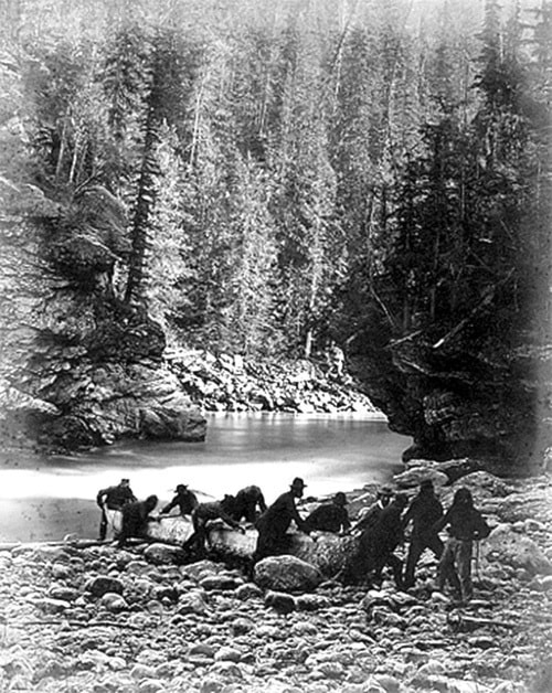
Accompanying Mr. Selwyn, was a photographer by the name of Benjamin F. Baltzly. His amazing pictures of the North Thompson River and region was known far and wide in Canadiana history.
Selwyn needed horses, a reliable guide, a “boss” packer and a reliable packer assistant. He was also in need of a camp cook, an “axe-man” and a translator. He already had a photographer and an emerging artist, and Selwyn soon found all he needed while in Kamloops in 1871.
John Peterson was the owner of the pack train, said to be 15 horses in total. He sold them to Selwyn who was financed by the federal government at that time. Mr. Peterson had used his pack train many times before, and his resume also included being an experienced packer, so was hired on in that capacity as well. The name of John Peterson would be very recognizable to the City of Kamloops, the land he resided on back in 1868 is now part of the present day city.
It is not clear how Abraham LaRue was hired on as a guide, translator and assistant packer for the survey party. It is clear though that Selwyn made a very good choice in hiring from the First Nations People.
Abraham proved his worth on many occasions in those fateful trips through Louis Creek and up the North Thompson.
It also appears that Abraham might have been the son of Joseph LaRocque, formerly of the NWC fur trading company (eventually Hudson’s Bay Company) in the early 1800’s. Joseph LaRocque may (can’t positively confirm) have come down the North Thompson through Louis Creek in 1812 to end up building a fort at Kamloops in that year.
It would be interesting to know if father and son had basically followed the same route in two different history events, years and years apart through this region.
Philip Jago was also of the First Nations. He had been hired on as an assistant to the survey.
Donald McPhail was the “axeman” for this group. His job would have been extremely strenuous to be swinging an axe all day to clear a path of obstacles.
James Dean was the camp cook. As with McPhail, these men had to have been in the Kamloops area at the time in order to be hired by Selwyn.
The expedition became horrendous once reaching this area.
The ruggedness of the untamed North Thompson proved to be too much for the survey party, and after several months of still not reaching their destination in the Jasper area, they made the decision to retrace their steps.
They arrived back in Kamloops on November 17, 1871.
All was not lost however. Though the geological aspect was never carried out to any high degree, the pictures of their expedition were superb.
If anyone would like to see the photographs taken by Mr. Baltzly, do a search through Google by typing “Benjamin F. Baltzly photographs”.
Article information courtesy of Louis Creek Heritage Trail Society and Carson Stone.