Mayson Campsite
This system of trails showcases pristine wilderness with exceptional fly fishing lakes. Some trails are relatively short, but very worthwhile and scenic. The trails north of Mayson Lake are on solid ground and offer a nice view of Bonaparte Lake. The area can be boggy in spots, so stay on the marked trails and be alert for marshy looking shorelines. Parking is limited in this area. Access roads are radio controlled.
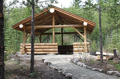
Mayson Lake Horse Camp has six camping spots in a well treed area suitable for high lining. There is an outhouse, shower house, picnic tables and fire rings, as well as a shelter.
Access:
From Barriere: Travel north from Barriere on Highway 5 for 18 km to Darlington Forest Service Road to 15.5 km, turn left onto Powder Lake Road, which is at 61.0 km, and drive to 50.2 km. Turn right for a very short distance; the camp is on the left.
From Kamloops: Travel Westsyde Road 20 km to Jamieson Creek Forest Service Road to 48.75; turn right onto Powder Lake Road which is at 49.0 km and drive to 50.2 km. Turn left for a very short distance, the camp is on the left.
Access to the trails start at this campsite. There are short trails from each campsite, taking you down to the shores of Mayson Lake.
History:
George and Lily Mayson homesteaded on the west side of the North Thompson River at McLure. George had bought the land previously in the year of 1900. George became a forest ranger, serving the Barriere and surrounding region in 1923. He was very well known and highly respected by the local community and by the Forestry Service Branch. He retired from that position in 1945.
Trail segment courtesy of Lower North Thompson Geocaching